Scientist tell us that the Grand Canyon region in northern Arizona, a small portion of western New Mexico, and southern Utah is ideal for the Mexican gray wolf because:
- The region has millions of acres of public land.
- Grand Canyon National Park, where animals are protected, is part of the region.
- There is an abundance of elk and deer as a food source for wolves.
- The region is connected to where wolves now live in the Blue Range Wolf Recovery Areas. If allowed, wolves will disperse naturally to the Grand Canyon region.
- There are few roads.
Wildlife biologists recommend that wolves be directly releases into the region. This can help restore the balance of nature and help the Mexican gray wolf recover from near extinction.
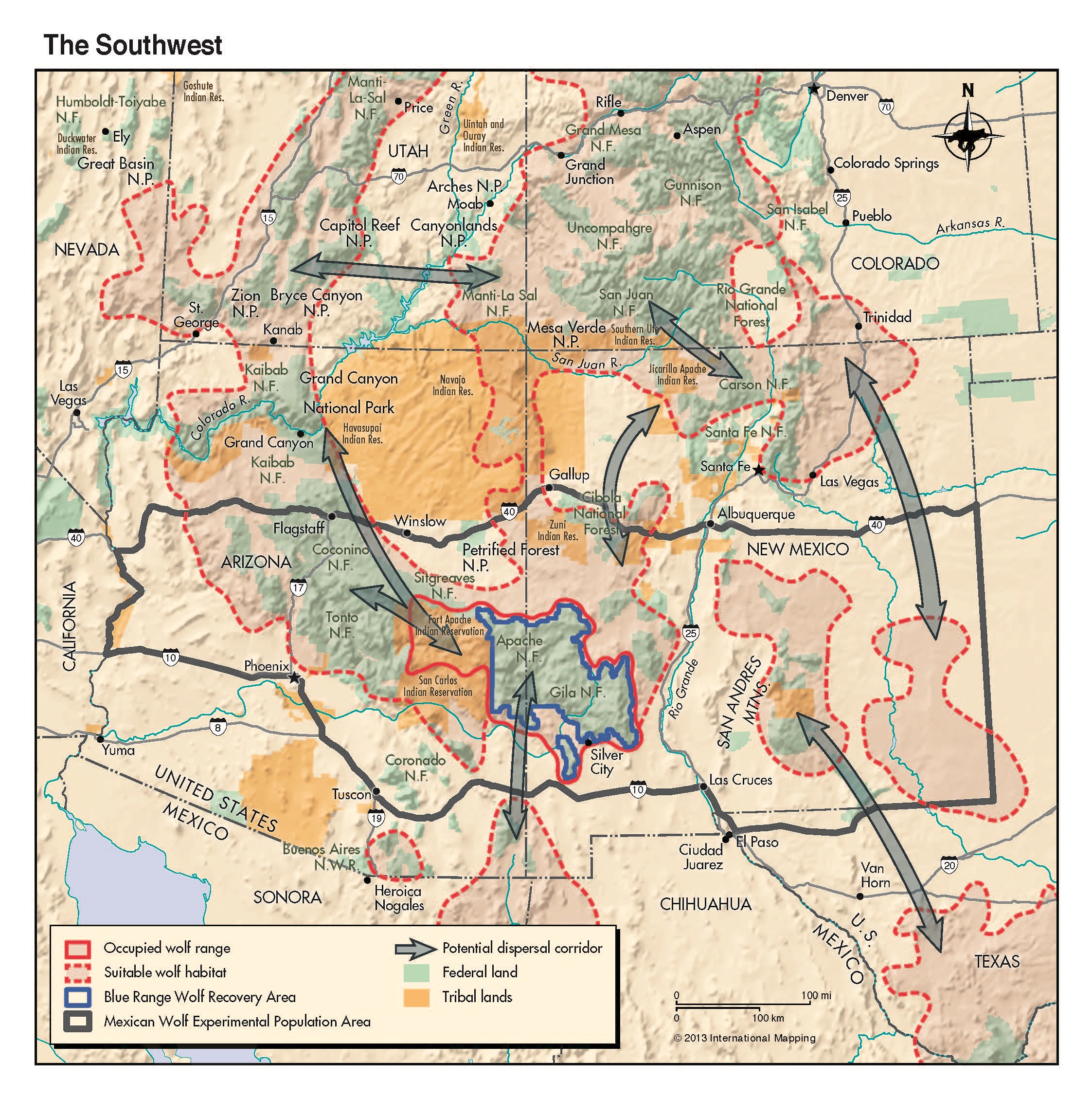
Potential suitable wolf habitat exists in several additional connected recovery areas of the Southwest and Mexico, including the Grand Canyon region (see the Southwest fact sheet). Please take a look at the Places for Wolves document by Defenders of Wildlife for more information. Map and Places for Wolves document and fact sheet courtesy of Defenders of Wildlife.
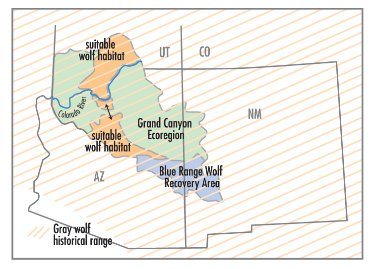
The 36 million-acre Grand Canyon Ecoregion (GCE) is bounded on the west by the Grand Wash drainage, on the east by the Little Colorado River watershed, and extends from the Mogollon Rim in central Arizona north to southern Utah’s High Plateaus. Scientists have conducted feasibility studies determining where within the GCE the best suitable habitat for wolves exists.
Scientific support for wolves in the Grand Canyon region:
- Sneed, P.G., 2001. The feasibility of gray wolf reintroduction to the Grand Canyon ecoregion. Endanger. Species Update 18, 153–158.
- Leonard J.A., C. Vilà, And R. K. Wayne. 2004. Legacy lost: genetic variability and population size of extirpated US grey wolves (Canis lupus). Molecular Ecology.
- Carroll, C., M.K. Phillips, and C.A. Lopez-Gonzalez. 2004. Spatial Anaysis of Restoration Potential and Population Viability of the Wolf (Canis lupus) in the Southwestern United States and Northern Mexico. Report prepared for the Turner Endangered Species Fund.
- Menke K. 2006. Modeling Potential Gray Wolf Habitat in the Grand Canyon Ecoregion. GIS model and presentation.
- Carroll, C., Phillips, M.K., Lopez-Gonzalez, C.A., Schumaker, N.H., 2006. Defining recovery goals and strategies for endangered species: the wolf as a case study. Bioscience 56, 25–37.
- Carroll, C. R. C. Lacy, R. J. Fredrickson, D. J. Rohlf, S. A. Hendricks, and M. K. Phillips. 2019. Biological and Sociopolitical Sources of Uncertainty in Population Viability Analysis for Endangered Species Recovery Planning. Nature: Scientific Reports, 9: 10130.
- Wayne, R. K., and P. W. Hedrick. 2011. Genetics and wolf conservation in the American West: lessons and challenges. Heredity 107:16–19.
- USFWS. 2012. Draft Mexican Wolf Revised Recovery Plan. 05-07-2012. USFWS Southwest Region (Region 2). Albuquerque, New Mexico. (Unauthorized release of this 2012 draft recovery plan was given to the public by AZGF Commissioner Husted and posted on the Big Game Forever website. This draft was further revised by the recovery team, but never finalized by the USFWS)
- Carroll, C., Fredrickson, R.J., Lacy, R.C. 2014. Developing metapopulation connectivity criteria from genetic and habitat data to recover the endangered Mexican wolf. Conserv. Biol. 28, 76–86.
- Crumbo, K. Mexican wolf life history. A summary with references.
- USFWS, 2014. Environmental Impact Statement for the Proposed Revision to the Regulations for the Nonessential Experimental Population of the Mexican Wolf (Canis lupus baileyi) Final. Albuquerque, New Mexico. Alternative 3
- Hendricks, S. A., P. R. Sesink Clee, R. J. Harrigan, J. P. Pollinger, A. H. Freedman, R. Callas, P. J. Figura, R. K.Wayne. 2016. Re-defining historical geographic range in species with sparse records: Implications for the Mexican wolf reintroduction program. Biological Conservation, 194, 48-57.
- Hendricks, S. A., S. Koblmüller, R.J. Harrigan, J.A. Leonard, R.M. Schweizer, B.M. vonHoldt, R. Kays, R.K. Wayne. 2017. Defense of an Expanded Historical Range for the Mexican Wolf: A Response to Heffelfinger et al. Journal of Wildlife Management DOI:10.1002/jwmg. 21336.
- Hedrick, P. W., R. K. Wayne, and R. J. Fredrickson. 2018. Genetic rescue, not genetic swamping, is important for Mexican wolves. Letter to the Editor. Biological Conservation, 224, 366-367.
- Root, K. V. and D. A. Kelt. 2020. Joint comments by the Society of Conservation Biology North America and American Society of Mammologist submitted to USFWS. Comment on Preparation of an Environmental Impact Statement on Revision to the Nonessential Experimental Population of the Mexican Wolf (Canis lupus baileyi) (Docket # FWS-R2-ES-2020-0007).
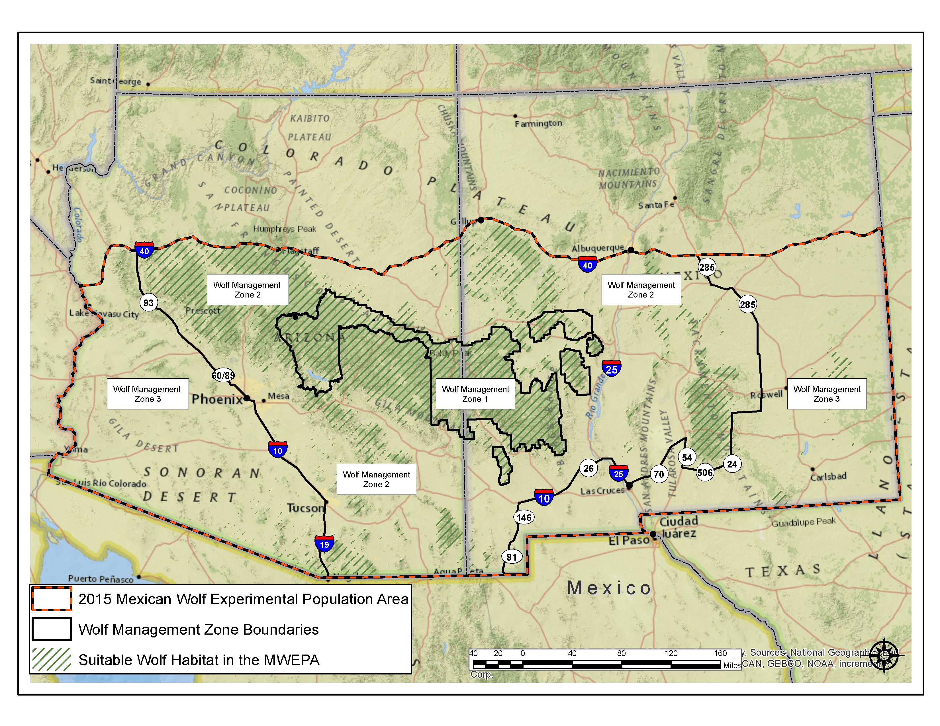 Map of the 2015 Mexican Wolf Experimental Population Area by USFWS. Currently, Mexican wolves are only allowed to live in the wild in the Wolf Management Zones 1 & 2 in Arizona and New Mexico and the Fort Apache Indian Reservation lands of the White Mountain Apache Tribe in Arizona (area not shown on map). A reintroduction project (also known as "10j") rule prohibits the wolves from establishing territories anywhere north of Interstate 40. Despite the excellent habitat that is available and growing public support for wolf recovery, Mexican wolves will not be allowed to disperse to the Grand Canyon region and stay until this boundary rule is changed.
Why are wolves currently being excluded from the Grand Canyon region?
Politics...
- 2010: AZGFD asks Congress to Delist Mexican wolves from ESA when population only 50 in wild (29 in AZ) so AZGFD can take over management
- 2011: Draft recovery plan by scientists says a core population needed in GCR of 250+ Mexican wolves leaked by AZGF Commissioner
- 2013: AZGFD asks USFWS to commit in writing and include provision in 10j rule to remove all wolves north of I-40
- 2014: AZGFD writes a “Cooperators Alternative” to the 10j DEIS (signed by counties, cattlegrowers assoc, and hunting groups). Adopted in the 2015 FEIS
- 2015: AZ, NM, UT, & CO Governors send letter to USFWS – want no wolves north of I-40
- 2016: Mexican wolf Recovery Planning Workshop – group agrees to cap model at I-40 for “geopolitical reasons” to exclude all northern habitat from 2017 recovery plan